


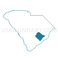
Cross Voting District, Berkeley County, South Carolina
About
Outline

Summary
| Unique Area Identifier | 665186 |
| Name | Cross Voting District |
| County | Berkeley County |
| State | South Carolina |
| Area (square miles) | 95.63 |
| Land Area (square miles) | 68.42 |
| Water Area (square miles) | 27.21 |
| % of Land Area | 71.54 |
| % of Water Area | 28.46 |
| Latitude of the Internal Point | 33.35235530 |
| Longtitude of the Internal Point | -80.20100290 |
Maps


Graphs
Select a template below for downloading or customizing gragh for Cross Voting District, Berkeley County, South Carolina


Neighbors
Neighoring Voting District (by Name) Neighboring Voting District on the Map
- Bonneau Beach Voting District, Berkeley County, SC
- Davis Station Voting District, Clarendon County, SC
- Eadytown Voting District, Berkeley County, SC
- Eutawville 1 Voting District, Orangeburg County, SC
- Eutawville 2 Voting District, Orangeburg County, SC
- Hilton Cross Roads Voting District, Berkeley County, SC
- Lebanon Voting District, Berkeley County, SC
- Pinopolis Voting District, Berkeley County, SC
- Russelville Voting District, Berkeley County, SC
- Wassamassaw No. 1 Voting District, Berkeley County, SC
Top 10 Neighboring County Subdivision (by Population) Neighboring County Subdivision on the Map
- Moncks Corner CCD, Berkeley County, SC (22,729)
- Manning CCD, Clarendon County, SC (13,826)
- Bonneau CCD, Berkeley County, SC (9,720)
- St. Stephen CCD, Berkeley County, SC (7,204)
- Cross CCD, Berkeley County, SC (7,104)
- Summerton CCD, Clarendon County, SC (6,541)
- Eutawville CCD, Orangeburg County, SC (5,021)
Top 10 Neighboring Unified School District (by Population) Neighboring Unified School District on the Map
- Berkeley County School District, SC (177,843)
- Orangeburg School District 3, SC (20,121)
- Clarendon School District 1, SC (8,920)
Top 10 Neighboring State Legislative District Lower Chamber (by Population) Neighboring State Legislative District Lower Chamber on the Map
- State House District 102, SC (37,248)
- State House District 64, SC (34,361)
- State House District 66, SC (32,845)
Top 10 Neighboring State Legislative District Upper Chamber (by Population) Neighboring State Legislative District Upper Chamber on the Map
- State Senate District 37, SC (116,420)
- State Senate District 44, SC (110,046)
- State Senate District 39, SC (88,126)
- State Senate District 36, SC (84,337)
Top 10 Neighboring 111th Congressional District (by Population) Neighboring 111th Congressional District on the Map
Top 10 Neighboring Census Tract (by Population) Neighboring Census Tract on the Map
- Census Tract 203.02, Berkeley County, SC (6,350)
- Census Tract 205.03, Berkeley County, SC (5,188)
- Census Tract 101, Orangeburg County, SC (5,021)
- Census Tract 201.02, Berkeley County, SC (3,931)
- Census Tract 9607.03, Clarendon County, SC (3,337)
- Census Tract 202.02, Berkeley County, SC (3,332)
- Census Tract 201.01, Berkeley County, SC (3,173)
- Census Tract 9608.02, Clarendon County, SC (2,935)
Top 10 Neighboring 5-Digit ZIP Code Tabulation Area (by Population) Neighboring 5-Digit ZIP Code Tabulation Area on the Map
- 29483, SC (66,731)
- 29148, SC (6,230)
- 29431, SC (6,071)
- 29048, SC (4,864)
- 29436, SC (4,471)
- 29468, SC (2,107)
- 29469, SC (855)